UN
6 Main Street
£ 162,000
Description
We don't have a Description for this property.
- Bedrooms
- 2
- Bathrooms
- 0
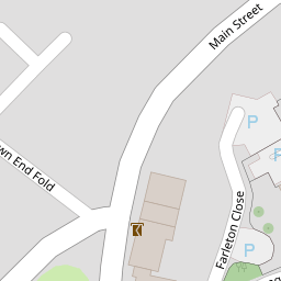


Leaflet © OpenStreetMap contributors
The heatmap indicates the level of crime in the area. The color of the heatmap indicates the crime severity and recency.
Metrics Year-on-Year
- Average area value
- 419,000.00 £Increased by 9.74 %
- Average area rental value
- 1,467.00 £/moDecreased by 6.50 %
- Est rental Yield
- 4.20 %Decreased by 14.81 %
- Crime Rate
- 11.00 %Unchanged by 0.00 %
from 381,826.00 £
from 1,569.00 £/mo
from 4.93 %
from 11.00 %
Nearby Schools
| Name | Type | Ofsted | Distance |
|---|---|---|---|
| Warton Archbishop Hutton'S Vc Primary School | Voluntary Controlled School | Good | 0.94 KM |
| Carnforth Community Primary School | Community School | Good | 1.82 KM |
| Carnforth Christ Church, Church Of England, Voluntary Aided Primary School | Voluntary Aided School | Good | 1.83 KM |
| Our Lady Of Lourdes Catholic Primary School, Carnforth | Voluntary Aided School | Good | 2.24 KM |
| Carnforth High School | Academy Converter | 2.44 KM |
Images
Nearby Streets
| Name | Average Price | Average Sqft | Distance |
|---|---|---|---|
| Town End Fold | £ 0 | 0 | 0.00 KM |
| Occupation Road | £ 1,000,000 | 0 | 0.00 KM |
| Briarscroft | £ 380,000 | 0 | 0.00 KM |
| Preston Street | £ 0 | 0 | 0.00 KM |
| Scotland Road | £ 0 | 0 | 0.00 KM |
Nearby Transport
| Name | NLC | TLC | Distance |
|---|---|---|---|
| Carnforth | 2640 | CNF | 1.48 KM |
| Silverdale | 1968 | SVR | 4.38 KM |
| Arnside | 1963 | ARN | 8.89 KM |
Nearby Listings
| Address | Price | Type | Score | Distance |
|---|---|---|---|---|
| Building Plot, 13a Main Street Warton, Main Street, Warton, Carnforth, LA5 9NR | £ 250,000 | BUY | 7 / 10 | 0.03 KM |
| Sand Lane, Carnforth | £ 290,000 | BUY | 6 / 10 | 0.24 KM |
| Westbourne Road, Warton, Carnforth | £ 279,950 | BUY | Unknown | 0.28 KM |
| Hutton Gardens, Warton, LA5 | £ 350,000 | BUY | Unknown | 0.34 KM |
| 46 Church Hill Avenue, Warton, Carnforth, Lancashire, LA5 9NU | £ 295,000 | BUY | Unknown | 0.34 KM |
Nearby Properties
| Address | Price | Distance |
|---|---|---|
| 12 Main Street | £ 112,500 | 0.00 KM |
| 4 Main Street | £ 275,000 | 0.00 KM |
| 2 Main Street | £ 180,000 | 0.00 KM |
| 6 Main Street | £ 162,000 | 0.00 KM |
| 10 Main Street | £ 130,000 | 0.02 KM |